Project Mission: Protecting Charlestown’s Navy Yard from Future Flooding Events
The Charlestown Navy Yard and Little Mystic Channel Flood Resilience Project is a coastal resilience initiative that aims to reduce risks from coastal flooding and rising sea levels while maintaining equitable access to the waterfront. This effort aligns with the City of Boston’s broader resilience strategies, and focuses on solutions that can be implemented quickly.
Project Goals and Objectives
The purpose of this project is to plan and develop feasible designs for capital improvements that reduce the risk of flooding in Charlestown. It will determine a preferred comprehensive plan and suggest a slate of short term projects that have the greatest potential to mitigate future flood impacts. This Project will: investigate and assess existing conditions, evaluate and update earlier strategies as outlined in the Coastal Resilience Solutions for East Boston and Charlestown (Phase II), 2022 (“CRS”), engage stakeholders, estimate construction costs, produce a cost/benefit analysis, develop early design and resilience guidelines and strategies to protect individual structures from flooding, and identify potential funding sources.
Work that is developed within the scope of this study will be used to create an implementation plan for neighborhood-scale flood resilience interventions, and help to identify any short-term capital improvements that can help address flood risks by 2030. The Project will build off of the climate vulnerability analysis and resilience strategies developed through Climate Ready Boston, 2016, and CRS Reports , to analyze site conditions, and develop implementable design options to help protect the Navy Yard from future sea level rise and coastal storm events. Preliminary designs for flood protection produced as part of this project will also serve as a foundation for federal and state grant applications, and future design development and construction in the Charlestown Navy Yard and Little Mystic Channel.
Project Location
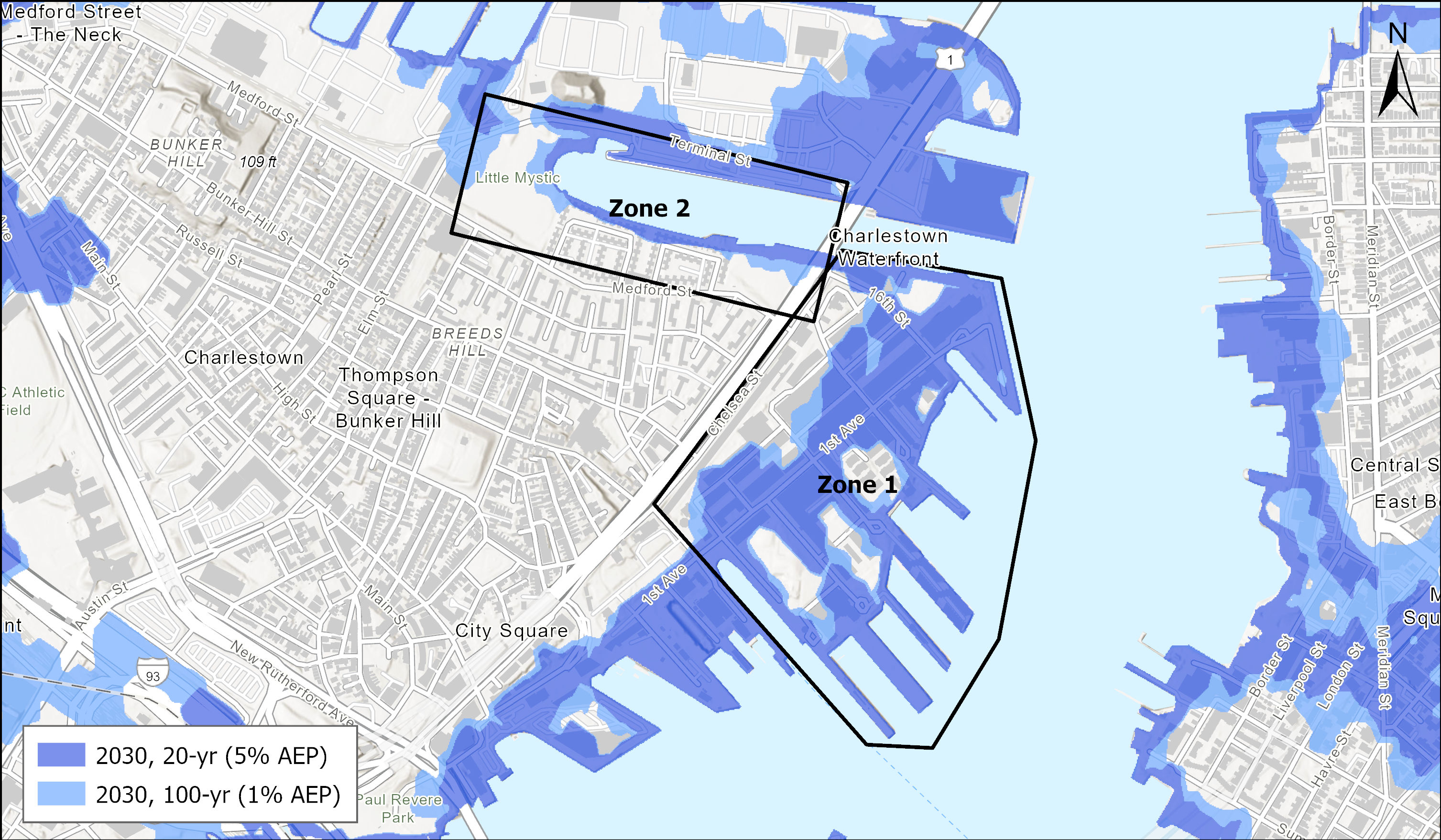
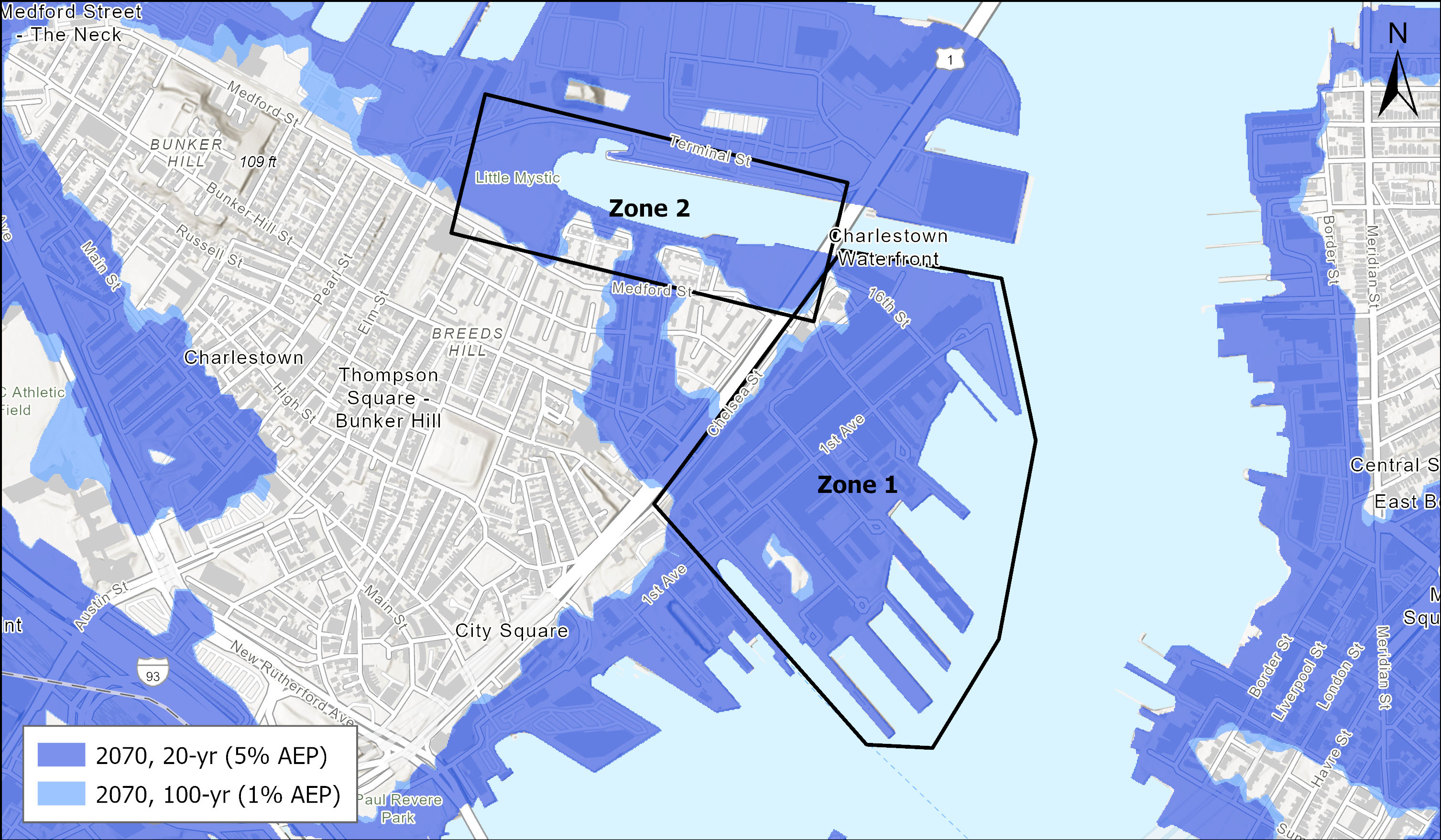
The Charlestown Navy Yard study area will include the harborside and adjacent properties between Pier 3 (a BPDA owned property) to the eastern edge of Barry Field (Zone 1) and the Harborwalk section from Barry Field all around the Little Mystic Channel (Zone 2) (the “Study Area”). These two zones will be the areas of focus for flood mitigation designs during this study, but many areas of the larger Charlestown neighborhood may benefit from the project. See Location Map below.

Proposed Outcomes
- Resilient Design: Propose flood-mitigation measures that protect the Navy Yard and Little Mystic Channel from future flooding events.
- Guidance for Immediate Action: Provide a roadmap for flood protection in the meantime that addresses pressing vulnerabilities.
- Long-Term Viability: Develop solutions that support the neighborhood’s long-term resilience and sustainability goals.
- Enhanced Waterfront Experience: Incorporate improvements that enrich the area’s recreational and community spaces while maintaining accessibility to the waterfront.
Why Is This Important?
Charlestown’s waterfront is a historic and vital part of Boston, serving as both a cultural landmark and a community hub. Strengthening its resilience against flooding is essential for protecting residents, infrastructure, and the area’s unique character.
Project Partners
The Project aligns closely with the National Park Service’s (NPS) flood resilience efforts along the Charlestown Waterfront expanding on the foundations set by Climate Ready Boston and Coastal Resilience Solutions initiatives. With the NPS project directly bordering the City of Boston’s study area, collaboration between both efforts is essential to strengthen flood protection, improve waterfront connectivity, and ensure a cohesive, long-term resilience strategy for the Charlestown Navy Yard.
In addition to the National Park Service, the project team is closely working with various federal and state agencies including the Massachusetts Bay Transportation Authority, Massachusetts Port Authority, Department of Conservation and Recreation, Boston Housing Authority, Boston Parks and Recreation, Boston Water and Sewer Commission, etc. Staff will also coordinate with the United States Army Corps of Engineers’ Coastal Storm Risk Management study.
The project team will ensure that Charlestown residents and important community organizations such as Mystic River Watershed Association and Friends of Charlestown Navy Yard, water-dependent organizations and businesses such as Courageous Sailing and Charlestown Marina, and healthcare providers such as Mass General Brigham are engaged in the process.
How to Get Involved
Residents and stakeholders are encouraged to participate in upcoming workshops and share their input to shape the project’s direction. Stay informed and engaged by signing up for notifications through our Get Involved page.
Article 25A
In October 2021, the City of Boston added a new zoning rule called Article 25A to help protect certain areas from flooding caused by rising sea levels and storm surges. The rule created the Coastal Flood Resilience Overlay District (CFROD), which sets guidelines for construction and development in flood-prone areas. The CFROD establishes clear steps for approving projects and ensures that buildings are designed to be resilient towards future flood risks. These guidelines are based on flood predictions from the Boston Harbor Flood Risk Model, and also promote walkable neighborhoods and sustainable designs. As the project is in a flood hazard zone, it must follow these resilient design standards to prepare for future flooding.
With your support, we can create a resilient and vibrant future for Charlestown's waterfront.
Still Have Questions?
For more information about the project, please contact:
Sabit Nasir
[email protected]
Senior Climate and Coastal Resilience Project Manager
City of Boston Planning Department
12 Channel Street , Boston, MA
Resources